Using new drone technology, a cosmopolitan crew of researchers have taken measurements from an active volcano, which could one day allow accurate early warnings of volcanic eruptions.
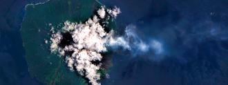
The crew, spearheaded by University College London (UCL) earth scientist Emma Liu, used modified drones to measure the gasses being released by Manam volcano in Papua New Guinea. Published in Science Advances, the study is a proof-of-concept for combining seismic, satellite, and drone data.
The project brought in specialists from volcanology and aerospace engineering to build drones capable of taking measurements from dangerously active volcanoes. While explosive volcanic eruptions are the most catastrophic and well-known form of volcanic activity, active volcanoes can release gasses — “degassing” — when not erupting.
Those observations are pretty tough to get; CO2 is prevalent in the atmosphere, meaning if you want to get accurate, you gotta get close. Active volcano vents, you will not be surprised to learn, are less than hospitable places.
The project modified long-range drones with gas sensors, spectrometers, and sampling devices that close automatically, and the team was able to fly the drone to Manam’s summit, 6km away and 2km up.
Using the drone-gathered gas sample, the team was able to suss out the sulfur/carbon dioxide ratio of Manam. This number is key to predicting volcanic eruptions because it is indicative of where the magma is; as volcanic eruptions approach, the proportion of carbon dioxide increases, escaping from bubbles in the roiling rock.
The drone’s data can be combined with measurements gathered from ground-level sensors and satellites. In 2018, volcanologists use drones to take similar measurements from two Central American volcanoes, Masaya and Turrialba.
Drones and disaster preparedness seem to go rotor-in-glove, whether as warning systems, speedy couriers, or gathering data from harsh terrain to better predict the next cataclysm — hopefully not supervolcanoes, but never count it out in 2020.
